DJI Phantom 4 RTK Professional Mapping Drone

Visionary Intelligence. Elevated Accuracy.

Upgrade your next mapping mission with the Phantom 4 RTK – the most compact and accurate low altitude mapping solution.

 image not found
 image not found

RTK Module

 image not found

1'' CMOS Sensor

 image not found

GS RTK APP

 image not found

TimeSync

 image not found

OcuSync

 image not found

D-RTK 2 GNSS

Mobile Station

1cm+1ppm

RTK Horizontal Positioning Accuracy

1.5cm+1ppm

RTK Vertical Positioning Accuracy

5cm

Absolute Horizontal Accuracy

of Photogrammetric Models

Premium Camera Performance

 image not found

Centimeter-Level Positioning System

A new RTK module is integrated directly into the Phantom 4 RTK, providing real-time, centimeter-level positioning data for improved absolute accuracy on image metadata. In addition to optimized flight safety and precise data collection, the Phantom 4 RTK stores satellite observation data to be used for Post Processed Kinematics (PPK), which can be conducted using DJI Cloud PPK Service. Fit the Phantom 4 RTK to any workflow, with the ability to connect this positioning system to the D-RTK 2 High Precision GNSS Mobile Station, or NTRIP (Network Transport of RTCM via Internet Protocol) using a 4G dongle or WiFi hotspot.

 image not found

Gather Accurate Data with TimeSync

To take full advantage of the Phantom 4 RTK’s positioning modules, the new TimeSync system was created to continually align the flight controller, camera and RTK module. Additionally, TimeSync ensures each photo uses the most accurate metadata and fixes the positioning data to optical center of the lens – optimizing the results from photogrammetric methods and letting the image achieve centimeter-level positioning data.

 image not found

Precise Imaging System

h a 1-inch, 20-megapixel CMOS sensor. Mechanical shutter makes mapping missions or regular data capture seamless as the Phantom 4 RTK can move while taking pictures without the risk of rolling shutter blur. Due to the high resolution, the Phantom 4 RTK can achieve a ground sample distance (GSD) of 2.74 cm at 100 meters flight altitude.To ensure each Phantom 4 RTK offers unparalleled accuracy, every single camera lens goes through a rigorous calibration process, with parameters saved into each image’s metadata, letting post-processing software adjust uniquely for every user.

 image not found

Purpose-Built Flight Planning Application

A new DJI GS RTK app and Remote Controller with built-in screen, giving users a streamlined control scheme for surveying missions and other data acquisition scenarios.The GS RTK app allows pilots to intelligently control their Phantom 4 RTK, with multiple planning modes, including Photogrammetry (2D and 3D), Waypoint Flight, Terrain Awareness, Block Segmentation, and more. Users can also import KML/KMZ files to optimize the workflow for their missions.With the built-in screen, pilots can clearly view and plan their missions on an ultra-bright, 5.5-inch HD display.

 image not found>

Access a Variety of 3rd Party Applications

Pilots with experience using 3rd party apps on DJI drones can access the world's leading drone app ecosystem for their Phantom 4 RTK with the SDK Remote Controller. Users can plug in a compatible Android or iOS device and install any compatible DJI Mobile SDK-enabled app to harness the full power of their Phantom 4 RTK.

 image not found

OcuSync Transmission System

Enjoy stable and reliable HD image and video transmission at distances of up to 7 km, great for mapping larger sites.

 image not found

Seamless Compatibility with D-RTK 2 Mobile Station

Support your Phantom 4 RTK missions with the D-RTK 2 Mobile Station – providing real-time differential data to the drone and forming an accurate surveying solution, or acquire accurate location coordinates when used as an RTK rover. The Mobile Station’s rugged design and OcuSync transmission system ensures you can gain centimeter-level accurate data with your Phantom 4 RTK in any condition.

Start Mapping Today

With a built-in flight planning app (GS RTK) and an easy method to collect RTK data (RTK Network or D-RTK 2 Mobile Station), pilots have a full solution for any surveying, mapping or inspection workflow – right out of the box.

 image not found
Skip to product information
1 of 5

DJI Phantom 4 RTK Professional Mapping Drone

DJI Phantom 4 RTK Professional Mapping Drone

Regular price $25,000.00
Regular price Sale price $25,000.00
Sale Sold out
Shipping calculated at checkout.

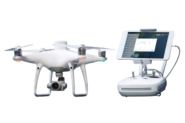
DJI Phantom 4 RTK - Redefining Drone Mapping Precision

The DJI Phantom 4 RTK revolutionizes aerial mapping with its built-in RTK module, delivering unmatched centimeter-level accuracy. Designed for professionals in surveying, construction, and agriculture, this drone ensures precise and efficient operations. Experience unparalleled data collection with reduced ground control points.

Key Features of the DJI Phantom 4 RTK

  • Built-in RTK module for centimeter-level positioning accuracy.
  • 1-inch CMOS sensor with 20 MP resolution for sharp imagery.
  • Flight time up to 30 minutes for extended operations.
  • TimeSync system ensures precise metadata alignment.
  • Compatible with D-RTK 2 Mobile Station for enhanced positioning.


For a comprehensive overview, Click here

Explore in-depth articles, tutorials, and guides on our Learn Page 

View full details

Talk to Our Team

Subscribe to get a 1 time discount!

Be the first to know about new collections and exclusive offers.