Law Enforcement
Drones are a Powerful Tool for Law Enforcement

Portable and Fast Aerial Response
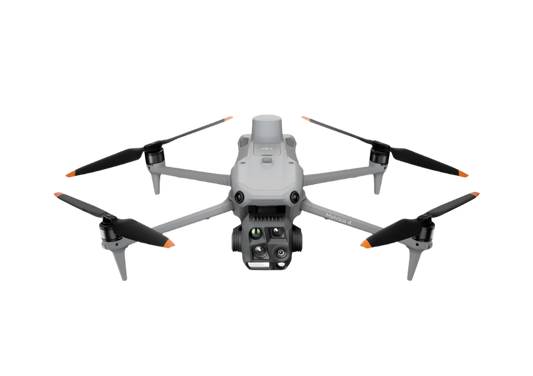
The Mavic 3T solution offers unparalleled portability for quick reconnaissance missions. Easy to carry on patrol vehicles and equipped with high-resolution visual and thermal sensors, it's an ideal solution for gaining intel on unexpected situations.
- Thermal and visual sensors to gather comprehensive aerial intel for your missions.
- Compact and lightweight design, less than 1kg and easy to carry in a patrol vehicle.
- Fast and easy deployment, get airborne in around 30 seconds.
- Superior flight performance with flight time of up to 45 min.
Drone Platform

DJI Mavic 3T
Weight: 920 g
Max Flight Time (no wind): 45 mins
Sensing type: Omnidirectional binocular vision system, supplemented with an infrared sensor at the bottom of the aircraft
Environment Adapbility: Max Take-off Altitude Above Sea Level 6000m; Max Wind Speed Resistance 12 m/s
Wide Camera: 1/2-inch CMOS, Effective pixels: 48 MP
Tele Camera: 1/2-inch CMOS, Effective pixels: 12 MP
Thermal Camera: Video Resolution 640×512@30Hz
Compatible with RTK module and DJI Cellular module
Payload And Software

DJI FlightHub 2
Drone and dock's cloud management system
DJI Pilot 2
Ground control
Workflow
- Mission Execution:
- Using DJI Pilot 2 App, add the target location to the map as a GPS Pin.
- Deploy the drone and manually fly towards the area of interest.
- In DJI Pilot 2 Camera View, use AR of the pin to guide the pilot toward the correct location.
- Activate discrete mode for night tactical or sensitive operations.
- Switch between infrared and visual views or use both at the same time to evaluate the situation and provide enhanced situational awareness to ground teams. - Post Mission Documentation:
- Upload the videos and images collected to DJI FlightHub 2 or download from the aircraft SD card for evidence reports or mission debrief.

Outdoor Overwatch Day or Night
The Matrice 350 RTK sets the standard for high-performance, multipurpose drone solutions. Equipped with the Zenmuse H30T multi-sensor payload, which includes zoom, wide, and thermal cameras, it provides optimal performance for law enforcement overwatch operations, day or night.
- Robust and weatherproof airframe graded IP55, allows you to fly when is most needed.
- Night Scene Mode and NIR Auxiliary Light features for night operations.
- Optimal operational efficiency with extended flight time of up to 55 min.
- Laser detection range up to 3,000 meters to get the accurate location of points of interest.
Drone Platform
Matrice 350 RTK
Weight: Approx. 6.47 kg(with single downward gimbal and two TB65 batteries).
Max Flight Time: 55 minutes.
Sensing system: Six-directional sensing and positioning.
Environment Adaptability: IP55, Max Service Ceiling Above Sea Level 7,000 m (with 1676 propellers,without other payload); Max Wind Resistance 12 m/s.
Payload And Software
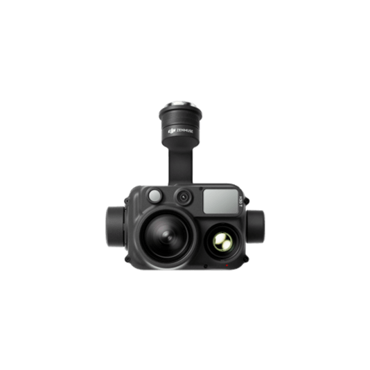
Zenmuse H30T
Weight: 920±5 g.
Ingress Protection Rating: IP54.
Zoom Camera:1/1.8-inch CMOS, Effective Pixels: 40 MP.
Wide-Angle Camera: 1/1.3-inch CMOS, Effective Pixels: 48 MP.
Infrared Thermal Camera: 1280×1024@30fps.
Laser Range Finder: max range 3000 m.
DJI FlightHub 2
Drone and dock's cloud management system
DJI Pilot 2
Ground control
Workflow
- Mission Execution:
- Using DJI Pilot 2 App, add the target location to the map as a GPS Pin.
- Deploy the drone and manually fly towards the area of interest.
- In DJI Pilot 2 Camera View, use AR of the pin to guide the pilot toward the correct coordinates.
- Activate discrete mode for night or sensitive operations.
- Switch between infrared and visual views to evaluate the situation and provide enhanced situational awareness to ground teams.
- Use the Smart Track function to keep track of moving objects while reducing pilot cognitive load.
- Pin locations of interest and easily center the camera on them. - Post Mission Documentation:
- Upload the videos and images collected to DJI FlightHub 2 or download from the aircraft SD card for evidence reports or mission debrief.