Search and Rescue
Thermal Imaging Drones For Search and Rescue

Portable Thermal
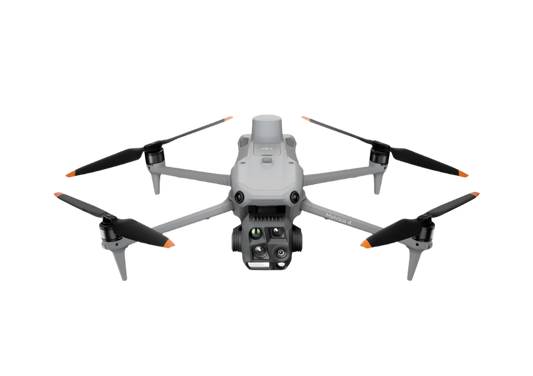
The Mavic 3T offers unparalleled portability and thermal capabilities for rescue teams. Easy to carry and equipped with visual and thermal cameras, it provides quick aerial support when time matters the most. Livestream the aerial feed to command centers through DJI FlightHub 2 for enhanced cross-team collaboration.
- Compact and lightweight design, less than 1kg and easy to carry in the response vehicle.
- Fast and easy deployment, get airborne in around 30 seconds.
- 640 × 512 thermal radiometric sensor for accurate temperature readings.
- Thermal palettes and temperature measurement tools for easy data interpretation.
Drone Platform

DJI Mavic 3T
Weight: 920 g
Max Flight Time (no wind): 45 mins
Sensing type: Omnidirectional binocular vision system, supplemented with an infrared sensor at the bottom of the aircraft
Environment Adapbility: Max Take-off Altitude Above Sea Level 6000m; Max Wind Speed Resistance 12 m/s
Wide Camera: 1/2-inch CMOS, Effective pixels: 48 MP
Tele Camera: 1/2-inch CMOS, Effective pixels: 12 MP
Thermal Camera: Video Resolution 640×512@30Hz
Compatible with RTK module and DJI Cellular module
Payload And Software
DJI Pilot 2
Ground control

DJI FlightHub 2
Drone and dock's cloud management system
Workflow
Mission Execution:
- Fly manually over the last known location following a search pattern such as the wheel route.
- Draw points, lines, or polygons on a map on DJI FlightHub 2 to mirror the last known location, trails, or key areas of interest.
- Select a suitable infrared palette and gain mode for the conditions at hand. White Hot and Black Hot palettes are preferred.
- Switch between infrared and visual cameras. Use the Link Zoom feature to zoom in simultaneously with thermal and visual sensors.
- As the situation allows, generate a rapid 2D map on DJI FlightHub 2 to provide a better understanding of search area and routes.
- Once the subject is identified, mark the location with the drone flying over.
- Communicate with the rescuee and rescue teams using the speaker if applicable.
- Support team on the rescue mission providing lighting from the drone using the spotlight.

Robust Multi-Purposed Search
The Matrice 350 RTK, equipped with the Zenmuse H30T, brings enhanced thermal capabilities to search and rescue teams. Add a spotlight and speakers to aid the ground team during rescue missions.
- Reliable multipurpose drone platform easily adapts to the mission needs.
- Powerful Infrared Sensor with 1280 × 1024 resolution provides superb thermal imagery.
- Robust and reliable, IP54 graded, allows you to fly when is most needed.
- Laser range finder to get accurate coordinates of objects up to 3,000 meters of range.
- Additional more powerful payload capabilities such as spotlight, speakers or drop systems to assist on the rescue mission.
Drone Platform
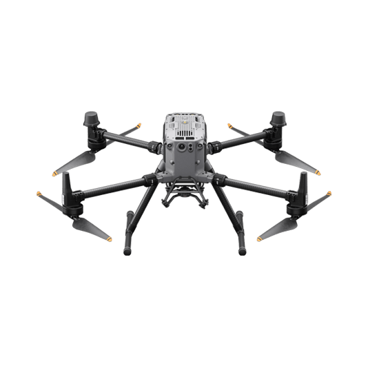
Matrice 350 RTK
Weight: Approx. 6.47 kg(with single downward gimbal and two TB65 batteries).
Max Flight Time: 55 minutes.
Sensing system: Six-directional sensing and positioning.
Environment Adaptability: IP55, Max Service Ceiling Above Sea Level 7,000 m (with 1676 propellers,without other payload); Max Wind Resistance 12 m/s.
Payload And Software
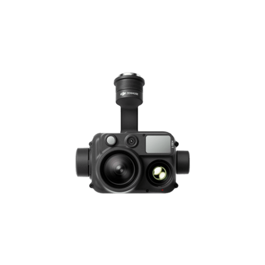
Zenmuse H30T
Weight: 920±5 g.
Ingress Protection Rating: IP54.
Zoom Camera:1/1.8-inch CMOS, Effective Pixels: 40 MP.
Wide-Angle Camera: 1/1.3-inch CMOS, Effective Pixels: 48 MP.
Infrared Thermal Camera: 1280×1024@30fps.
Laser Range Finder: max range 3000 m.
DJI Pilot 2
Ground control
DJI FlightHub 2
Drone and dock's cloud management system
Workflow
Mission Execution:
- Fly manually over the last known location following a search pattern such as the wheel route.
- Draw points, lines, or polygons on a map on DJI FlightHub 2 to mirror the last known location, trails, or key areas of interest.
- Select a suitable infrared palette and gain mode for the conditions at hand. White Hot and Black Hot palettes are preferred.
- Switch between infrared and visual cameras. Use the Link Zoom feature to zoom in simultaneously with thermal and visual sensors.
- For night missions, operators can choose to disable the IR Cut filter and enabling the IR spotlight of the zoom camera for enhanced night visibility.
- As the situation allows, generate a rapid 2D map on DJI FlightHub 2 to provide a better understanding of search area and routes.
- Once the subject is identified. Get the coordinates of subject using the laser range finder and the Pin Point function or draw out routes and areas to avoid.
- Share Pin Point coordinates to ground teams through DJI Pilots 2 QR code or DJI FlightHub 2.
- Communicate with the rescuee and rescue teams using the speaker if applicable.
- Support team on the rescue mission providing lighting from the drone using the spotlight.